Outdoor Living

Streamline outdoor projects with drone photogrammetry—perfect for pool builders, landscapers, and hardscapers.

🛠️

Practical Solutions in Action

🌿 Built for Outdoor Living Pros

  • 📸 Showcase your work with stunning visuals
  • 🧭 Help clients decide faster with clear designs
  • 📈 Win more bids with polished presentations
  • 🕒 Save time on client communication
  • 🤝 Build trust with branded, pro-level materials
  • 🔧 Get flexible support—design, marketing, and more


🧠

Smarter Design, Faster

Estimates, Better Planning

Estimate with Confidence: Precision Starts from Above

ProTerra Imagery simplifies estimating for landscapers with precise drone mapping, topographic data, and detailed 3D models—removing guesswork and cutting costly errors.


Our services help you:


📐 Capture accurate elevation changes, boundaries, and existing features


🧮 Create faster, data-driven estimates with digital takeoffs


🚫 Minimize site visits while maximizing efficiency


💰 Boost profitability and build client trust with clear proposals


Whether it’s hardscaping, irrigation, grading, or full outdoor living projects, ProTerra Imagery helps you estimate with confidence and win more work.


Sell the Vision: Close More Deals with Powerful Visuals

ProTerra Imagery helps landscapers close more deals with high-res drone mapping and stunning 3D renderings that bring designs to life.


With our services, you can:


🎯 Present accurate site measurements and realistic visualizations


📸 Showcase before-and-after imagery to wow clients


💻 Enhance proposals, websites, and social media with eye-catching content


🚫 Reduce errors and revisions with precise planning


🌿 Stand out in hardscaping, outdoor living, or garden design


Impress clients, build trust, and grow your business with visuals that sell.


Plan with Precision: Build Smarter from the Ground Up

ProTerra Imagery makes landscape planning easier and more precise with high-resolution drone mapping, topographic surveys, and 3D site models.


Our services help you:


📏 Capture accurate terrain, elevation, and structure data


🧱 Improve design accuracy and material planning


🚧 Spot potential issues before construction begins


📸 Present realistic previews to clients


⏱ Streamline workflows and reduce costly rework


From hardscaping to irrigation and outdoor living, we give you the tools to plan smarter and deliver flawless results.


Market with Impact: Visuals That Speak Louder Than Words

ProTerra Imagery helps landscapers market their services with high-res drone mapping and stunning 3D visualizations.


With our visuals, you can:


🖼 Show before-and-after designs that wow clients


🎯 Boost proposals with realistic, immersive previews


💬 Increase client confidence and close more deals


📸 Capture finished work in detail for marketing and portfolios


🚀 Stand out online and position yourself as a leader in your field


Impress, convert, and grow with visuals that speak for themselves.


Deliver with Confidence: Quality You Can See from Every Angle

ProTerra Imagery helps landscapers maintain top-tier quality control with high-accuracy drone mapping, site monitoring, and detailed 3D models.


Our tools help you:


🛰 Track project progress and catch issues early


📏 Verify grading, drainage, and material placement


🧭 Compare as-builts to design specs for accuracy


🔄 Make data-driven adjustments before costly mistakes


✅ Ensure consistent, high-quality results across every phase


Whether it’s hardscaping, irrigation, or full outdoor makeovers—deliver work that exceeds expectations, every time.


🚀 Assets That Elevate Your Brand (and Your Bids) 🚀

Design Services

ProTerra turns ideas into clear, compelling 3D visuals—built on drone data to boost trust and drive sales


Here’s how we help you close faster and sell smarter:


  • 🧠 Visual Clarity – Life-like 3D models make it easy for clients to understand your vision.
  • 🤝 Build Confidence – Realistic designs boost trust and help customers commit.
  • 💬 Better Communication – Eliminate confusion and align expectations from the start.
  • Faster Sales Cycle – Address concerns early and speed up decision-making.


Let ProTerra Imagery bring your ideas to life—and help your clients say “yes” with confidence.

Orthomosaic & 3D Environments

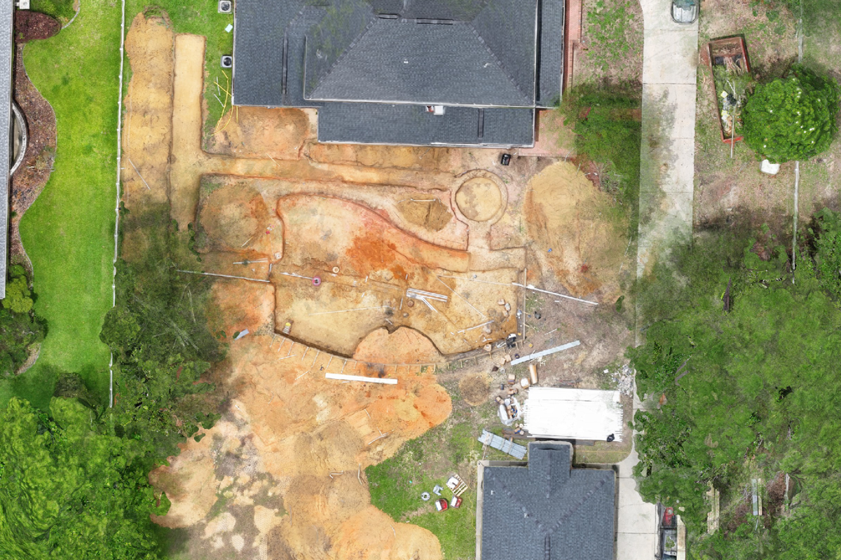
Trench dug, ready to backfill—what if you could see underground without digging? With ProTerra, you can.


Our cutting-edge drone scanning services provide:


  • 🔍 Pre-backfill visibility – Capture buried utilities, components, and obstacles before they're covered
  • 🧠 Smarter planning – Use AR to visualize what's underground with a tap
  • Fewer surprises – Avoid rework, delays, and costly mistakes
  • 🤝 Greater trust – Show your clients exactly what’s happening beneath the surface


ProTerra: Clarity that goes beyond the surface.

Effortless & Accurate Take-Offs

Precision drone mapping for landscapers and outdoor pros—detailed site data, 3D models, and orthomosaic maps delivered fast.


With our services, you get:


  • 📏 Centimeter-level accuracy – Measure distances, areas, and volumes with confidence
  • 🛠 Streamlined planning – Eliminate guesswork with reliable, visual data
  • 🧱 Better material estimates – Visualize dimensions and calculate materials in seconds
  • 🤝 Stronger client trust – Present clear plans that reflect your commitment to quality


Plan smarter. Build better. Win more—with ProTerra Imagery.

🚀

Assets That Elevate Your Brand (and Your Bids)

  • Estimating

    ProTerra Imagery simplifies estimating for landscapers with precise drone mapping, topographic data, and detailed 3D models—removing guesswork and cutting costly errors.


    Our services help you:


    📐 Capture accurate elevation changes, boundaries, and existing features


    🧮 Create faster, data-driven estimates with digital takeoffs


    🚫 Minimize site visits while maximizing efficiency


    💰 Boost profitability and build client trust with clear proposals


    Whether it’s hardscaping, irrigation, grading, or full outdoor living projects, ProTerra Imagery helps you estimate with confidence and win more work.

    Case Study
  • Sales

    ProTerra Imagery helps landscapers close more deals with high-res drone mapping and stunning 3D renderings that bring designs to life.


    With our services, you can:


    🎯 Present accurate site measurements and realistic visualizations


    📸 Showcase before-and-after imagery to wow clients


    💻 Enhance proposals, websites, and social media with eye-catching content


    🚫 Reduce errors and revisions with precise planning


    🌿 Stand out in hardscaping, outdoor living, or garden design


    Impress clients, build trust, and grow your business with visuals that sell.

    Case Study
  • Planning

    ProTerra Imagery makes landscape planning easier and more precise with high-resolution drone mapping, topographic surveys, and 3D site models.


    Our services help you:


    📏 Capture accurate terrain, elevation, and structure data


    🧱 Improve design accuracy and material planning


    🚧 Spot potential issues before construction begins


    📸 Present realistic previews to clients


    ⏱ Streamline workflows and reduce costly rework


    From hardscaping to irrigation and outdoor living, we give you the tools to plan smarter and deliver flawless results.

    Case Study
  • Marketing

    ProTerra Imagery helps landscapers market their services with high-res drone mapping and stunning 3D visualizations.


    With our visuals, you can:


    🖼 Show before-and-after designs that wow clients


    🎯 Boost proposals with realistic, immersive previews


    💬 Increase client confidence and close more deals


    📸 Capture finished work in detail for marketing and portfolios


    🚀 Stand out online and position yourself as a leader in your field


    Impress, convert, and grow with visuals that speak for themselves.

    Case Study
  • Quality Control

    ProTerra Imagery helps landscapers maintain top-tier quality control with high-accuracy drone mapping, site monitoring, and detailed 3D models.


    Our tools help you:


    🛰 Track project progress and catch issues early


    📏 Verify grading, drainage, and material placement


    🧭 Compare as-builts to design specs for accuracy


    🔄 Make data-driven adjustments before costly mistakes


    ✅ Ensure consistent, high-quality results across every phase


    Whether it’s hardscaping, irrigation, or full outdoor makeovers—deliver work that exceeds expectations, every time.


    Case Study

🖼️

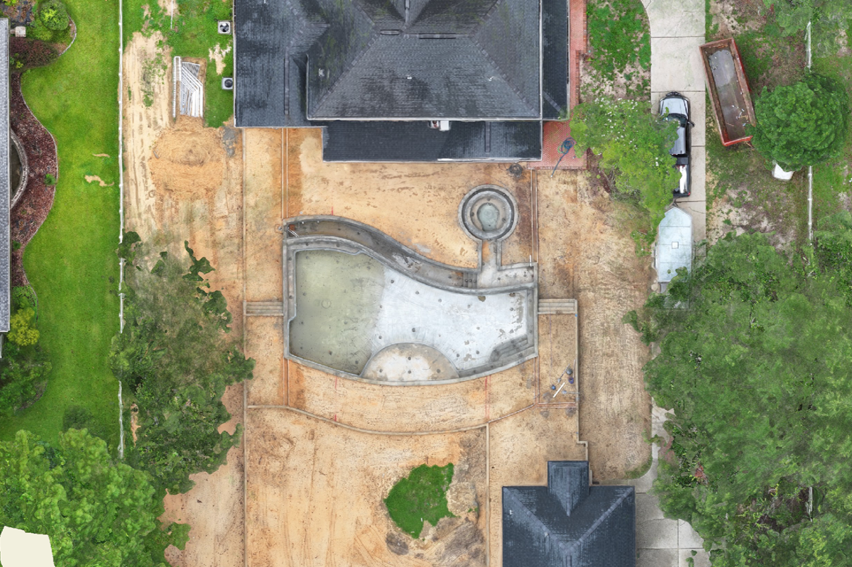
Showcase Your Work with Before & After Visuals

🔄

Stay on Track with Ongoing Aerial Updates

Contact Us

Eastern Alabama & the Gulf Coast Region

850-805-6937

Info@proterraimagery.com

Contact Us